Feeds:
Posts
Comments

Posts Tagged ‘Paddling’

The rain came in torrents the night before, and I woke to partly cloudy skies and a chance of more rain.    I called Canoe Escape in Thonotosassa for a weather report, and I was a bit surprised when the guy on the other end chirped, “Skies are clear here!”  So, off I went to discover the Hillsborough River.

The Wild Hillsborough River

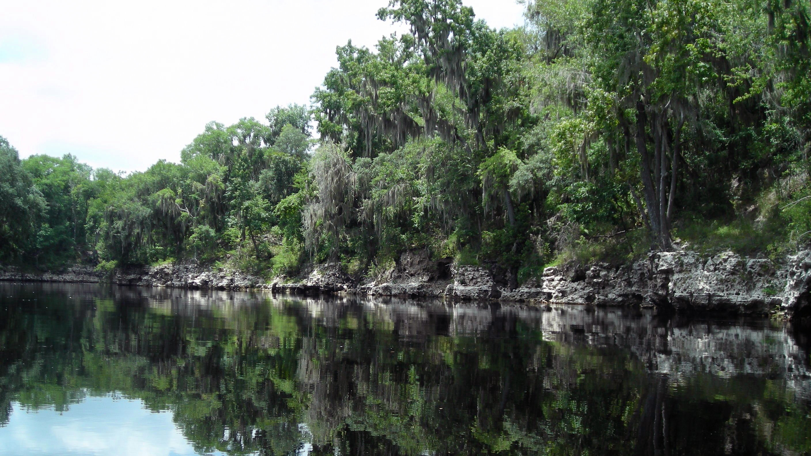
Originating in the Green Swamp, the Hillsborough is a black water river and largely spring fed by the waters of Crystal Springs (south of Zephyrhills), accounting for its clarity—even after a hard rain.  Along its 54-mile journey, several tributaries feed into it before it empties into the Tampa Bay.  Throughout the years, this river has had  several names, but it was finally named Hillsborough River by the British in 1769 after the Earl of Hillsborough who served as colonial secretary of state (Boning).

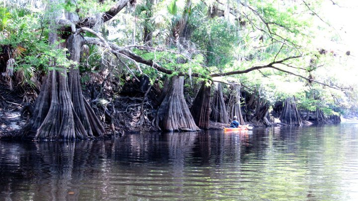
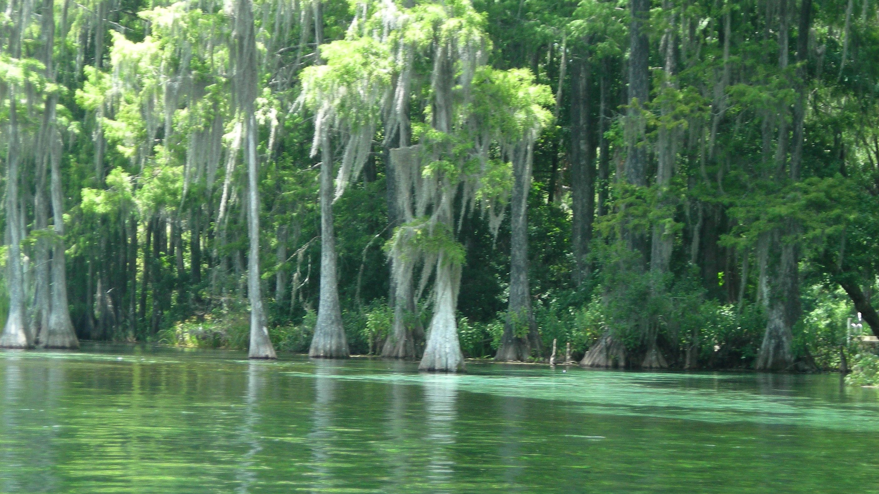
On this Sunday morning, I rented a sit-inside kayak from the Canoe Escape outfitters and was dropped at Sargeant Park, where I had an option of paddling two hours downstream to Morris Bridge Park or four hours to Trout Creek Park.  I opted for the four-hour paddle, and was rewarded with a journey through a river wonderland.  This river was absolutely beautiful—an A+–with water often clear enough for me to see not only the eel grass swaying along the sandy bottom, but many bass, gar, and sucker fish as well.

And there were many, many alligators.  Within my first 30 minutes on the river, I  had already sighted 20 gators.  It appears that alligators are to the Hillsborough what turtles are to the Santa Fe.  By the end of my paddle, I had seen somewhere between 50 and 100.  It was obvious that these gators were at home in their habitat, and although they were not aggressive, they weren’t moving from their favorite spot just because I was there, either.

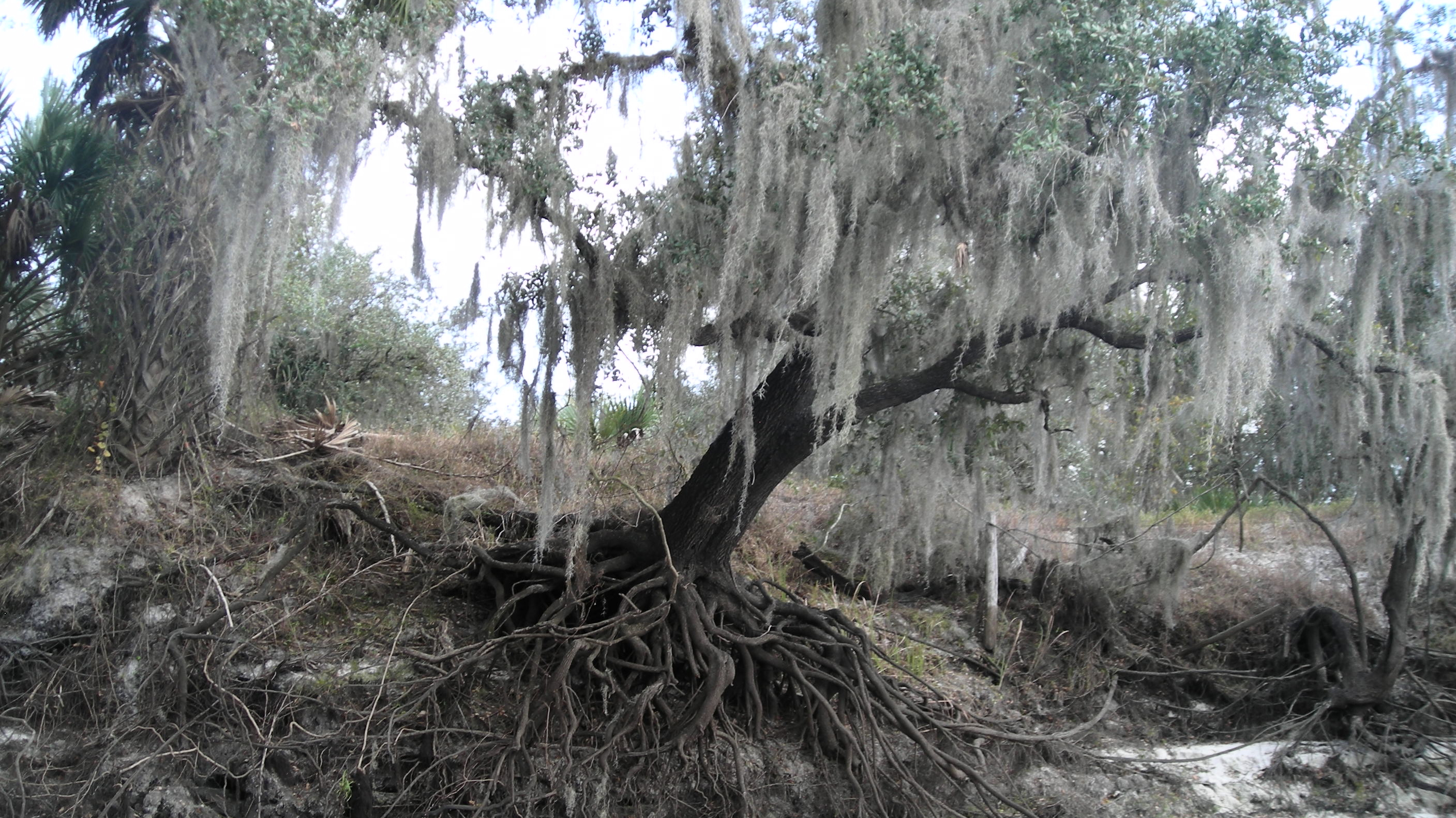
Beautiful, serene, and wild.  My paddle was—AWEsome.  I was in the midst of a bird paradise with a sweet symphony playing in the trees as the water pulled me gently along like a ride at Disney.  A great egret turned toward me, looking silly with white sand on the end of his bill, having just dug for some treasure.  A momma limpkin enjoyed a day at the river with her two young ones. Anhingas spread their wings to dry them in the sun.  Egrets, herons, limpkins, roseate spoonbills, woodpeckers, wood storks, and ibis were plentiful.  At one point in the journey, I passed Nature’s Classroom, and hundreds of vultures, seemingly wicked as they flapped their wings and congregated along the bank, took it all in.

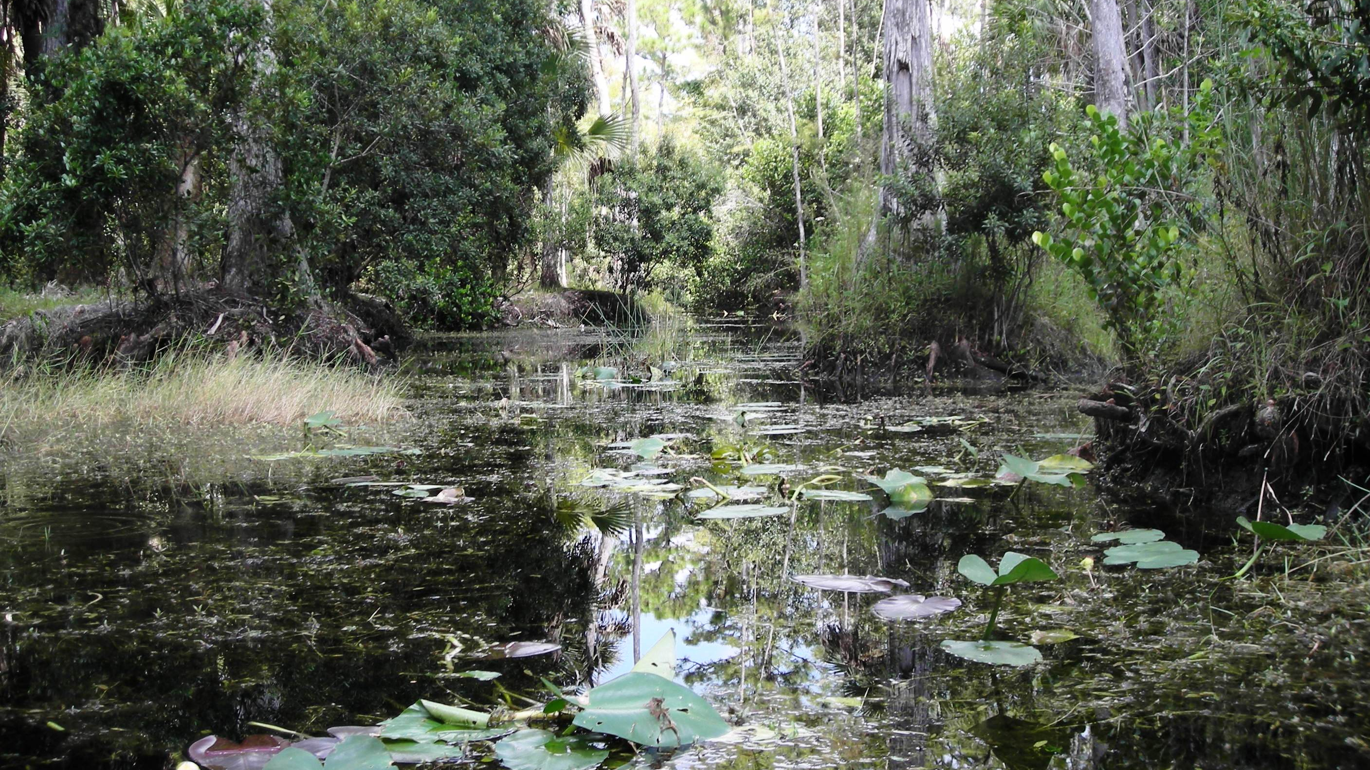
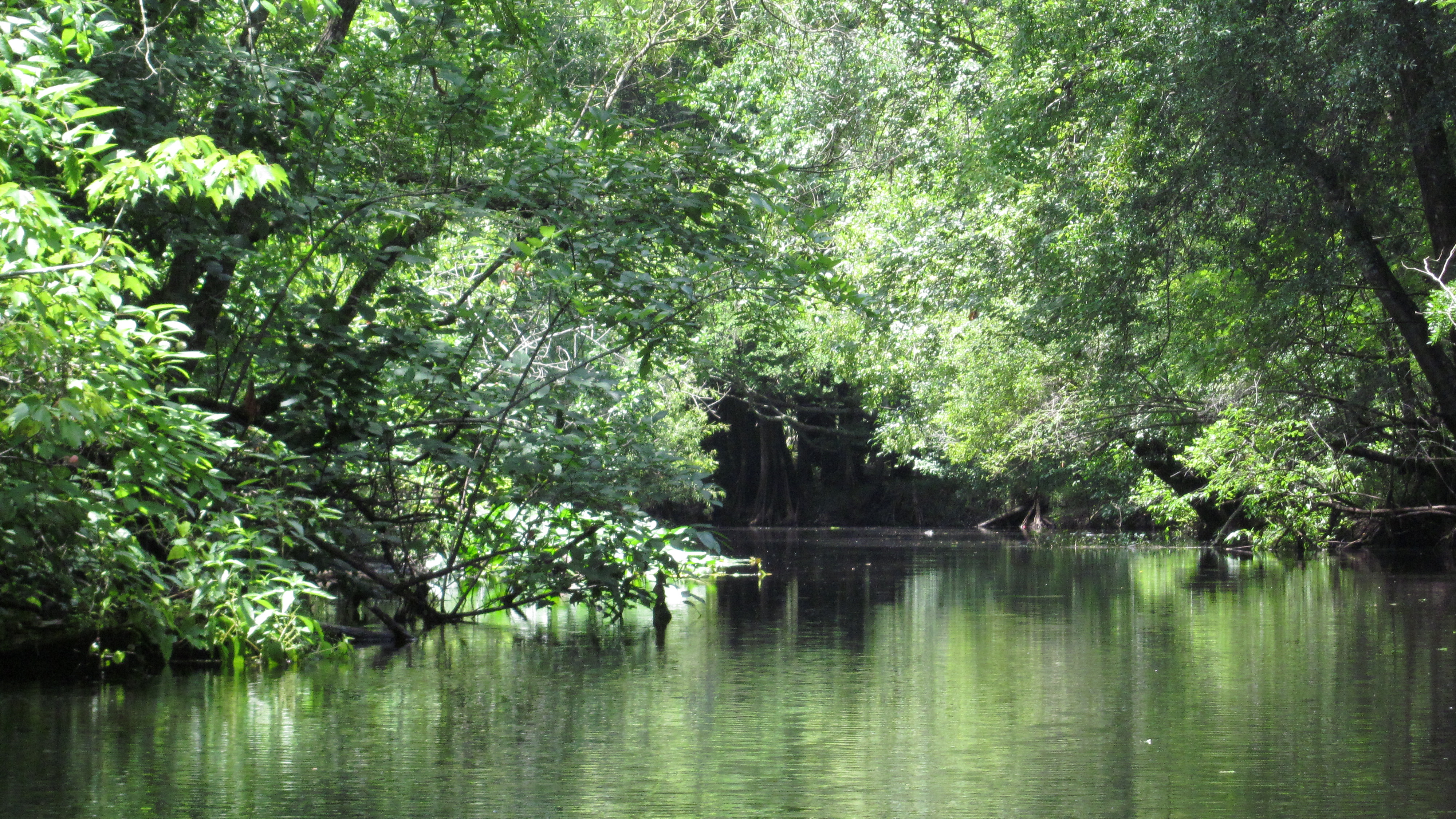
The river was shaded, canopied for much of the trip by oaks, red maples, cypress, and an occasional sweetgum.  At times, the river was narrow and twisted and turned.  (I thought I had made a wrong turn at one point.)  When the river widened, water lilies and hyacinths decorated its edges.

It was impossible to see it all.  Watching a gator slither into the water to my left, I heard a huge splash to my right and turned just as an osprey lifted himself from the water.  An otter frolicked in the water, finally emerging with his hair slicked back, looking ready to don his smoking jacket.  The harmony and balance of nature amazed me.

I paddled just two small sections of this river, but there is so much more to it.  Other sections include a six-mile run from Crystal Springs to Hillsborough State Park (not for the beginner; there are three Class II drops/rapids and many portages in this section.)  The section from Hillsborough State Park to Sargeant Part where I put in, contains the Seventeen Runs with numerous deadfalls and carryovers. At this time of year with the low water levels, the Seventeen Runs section is closed.  However, for anyone interested, Canoe Escape takes a group out once a year in September.

Another beautiful Florida river, the Hillsborough is a wonderfully and surprisingly scenic and serene escape.

Outfitter: Canoe Escape. 9335 East Fowler Avenue, Thonotosassa, FL 33592. https://www.canoeescape.com/. (813) 986-2067)

Read Full Post »

My friend, Bill Belleville, and I headed to the Econlockhatchee River for a paddle the Saturday morning before Easter, pleased to find the river was quiet when we arrived.  A few sleepy campers emerged from the woods with blankets and pillows just as we carried our kayaks down to the launch area.  We finished loading our supplies, lathered on some sunscreen, and off we went.

The Intriguing Econ River

A state-designated canoe trail, the Econlockhatchee River originates in the Econlockhatchee River Swamp in northern Osceola County.  Its tea colored waters flow first north and then northeast for approximately 35 miles, eventually emptying into the St. Johns River (Boning).  Along its journey, the river passes through private ranch lands and state protected forests.  It passes through the Little Big Econ State Forest before emptying into the St. Johns River.

The Econ can be paddled in several sections; however, little rain in recent years has resulted in low water levels, in some areas, too low to paddle.  If we paddled the first section, between FL 50 and the CR 419 bridge, we would have struggled with numerous carryovers.  Paddling the next section, between the CR 419 bridge and the Snow Hill Road bridge, would have meant leaving our cars in a remote area.  So, we chose the third section, and we put in at Snow Hill Road between Geneva and Chuluota and paddled northeast toward the St. Johns River. 

I have to pause for a moment here and say, that there isn’t a better way to experience a river than traveling with a nature writer and conservationist, such as Bill Belleville.  He can identify most of the flora and fauna along the river, and is tremendously patient with all my questions.  In his most recent book, Salvaging the Real Florida: Lost and Found in the State of Dreams, Bill dedicates at least one chapter to Florida rivers and describes one of his previous paddles on the Econ after tropical storms had, as Bill writes, “filled its valley of paleo-dunes to overflowing.”  The river he described at that time was much different than the river we experienced on this day.

Intriguing rather than beautifully lush, the landscape of our Econ run varied from high sandy banks to low sandy beaches.   At times, towering cypress dwarfed us as we paddled past, water marks on their trunks evidence of higher water levels.  Of course, there were oaks and cabbage palms, and we even spotted a couple magnolia trees nudging themselves between the larger trees.  However, without the benefit of spring waters and with little or no rain in the area for a very long time, the water level was low, leaving the worn, depleted banks with trees clutching to their sides.  At times, deadfalls challenged us, as we were forced to paddle either through or over them. 

Amazingly, the low water level did not deter the birds as we saw many!  We spotted three bald eagles, one quite large, and we were treated to a great blue heron that seemed to await us at each river bend, flying off as we approached, to scout ahead.  We saw blue herons, swallow-tailed kites, vultures, and red- shouldered hawks.  Bill even spied a wild turkey just before it ducked behind a log.  Two alligators crossed our path—the larger one, about 10 feet long, slid into the water ahead of us, pausing while we paddled closer, and then disappeared slowly somewhere beneath us.

There never seems to be enough time when paddling a Florida river.  We had hoped to make it to the St. Johns, about a 12-mile run.  However, after two hours of paddling and a short snack break and nature scout, we turned around and headed back to Snow Hill Bridge.

I’d love to return to this river someday—after a tropical storm, when its “valley of paleo-dunes” are overflowing–and paddle the entire 35 miles.  It was a beautifully intriguing river with so much character.

Read Full Post »

New Year’s Day, a time for reflection and resolutions, and I found myself drawn to the Peace River in Arcadia.  Paddling the Peace seemed appropriate and reinforced a resolution I had already made to myself, to stay in the moment and to seek joy in living.

Clutching to the Banks of the Peace River

The Peace River is a black water, coastal river which originates with waters from Lake Hancock in Polk County around Bartow, and after 76, 106, or 133 (I’ve read all three!) miles, it ends as it expels its water into the Charlotte Harbor estuary.  At least two different stories explain how the Peace River got its name, but the one I hear most frequently is that the Spanish had named it Rio de la Paz, “river of peace,” way back in the 1500s (Huff).

So, on New Year’s Day, the Canoe Outpost folks put me in at the Brownville landing around noon just as the sky clouded over and the breeze picked up.  Paddling downstream into the wind felt more like paddling upstream until a bend in the river brought relief.  Brownville is north of Arcadia, where my paddling excursion would end.  The area is mainly agricultural and ranch lands, and at this time of year, everything was, indeed, brown.

Although Katie at the Canoe Outpost told me it was a slow day on the river, I passed a number of kayakers and canoers.  Some were simply enjoying the paddle while others were fishing or panning for fossils, shovel in one hand and strainer in the other.  I’ve heard that many find treasures such as giant sharks’ teeth, mastodon teeth, and other prehistoric fossils.  This river has so much history.  In the 1700s, Seminoles settled along its banks, and several conflicts took place there (Boning).   In the 1900s, barges traveled up and down the Peace to mine phosphate and harvest cypress logs (Huff).   I saw a very large hole at the top of one of the banks when I made a stop at Oakhill (owned by Canoe Outpost).  At first I thought this was a sink hole, but perhaps it was the remnants of a phosphate dig.

Lacking the green lushness of most of my previous paddles, there was still a beauty in the various shades of brown along the white sandy banks (think “golden brown meringue”).  The river was wide and varied ranging from high banks to low sandbars.   Live oaks draped in silver moss hung from the banks, their huge root systems twisting and reaching for something to stabilize them, the soil beneath them eroded away.  The cypress had lost their foliage.  Dead, fallen trees decorated the river like pieces of abstract art along a city street.

The dark water was cool and slow moving except for occasional shoals and incoming streams.  I saw turtles, herons, egrets, hawks, and vultures.   Carter et al. gave the Peace River a “B,” although she gave another section—Zolfo Springs to Garner—an “A.”  I would concur with the “B” on this segment (and as an instructor, I would add that it’s still a good grade!).  Keep in mind that my paddle was only 10 miles and one segment of about 61 miles and nine segments that can be navigated.  If you consider a paddle on the Peace, check out Huff’s guidebook and her descriptions of each of these segments.

(Canoe Outpost-Peace River. 2816 NW County Rd. 661, Arcadia, FL 34266. http://canoeoutpost.com/coicontactus.html. (863) 494-1215 or (800) 268-0083)

Read Full Post »

The Loxahatchee River was the first of two Florida rivers designated as a Wild and Scenic River (the second being the Wekiva River), a well-deserved designation.  Its name comes from an old Indian name which means, “river of turtles.”  This area has historic relevance.  During the Second Seminole War in 1838, the Battle of Loxahatchee was fought in the area now known as Riverbend Park.  I saved the Loxahatchee River for a Sunday in September because I wanted to paddle the Riverbend Park section which had been closed in August due to the low water level.

The Lovely Loxahatchee River

From the beginning, I knew this would be a fun paddle.  The man at Canoe Outfitters pulled out a map–which had been copied way too many times–and with a line forming behind me, he very quickly outlined the five mile run.  It went something like this: “After you put in, go to the left and paddle about three quarters of a mile.  You’ll see a small sandy beach on your left where you need to drag your kayak out and to the other side.  From there, you will turn right and head toward West Lake.  On the south side of West Lake you exit to Hunter’s Run which will take you under Reese’s Bridge to South Pond.  Continue on Hunter’s Run to the East Grove Bridge.  You’ll see a spot where you can beach and stretch your legs, and from there you will paddle to Cow Pond Lake and exit to Gator Slough run.  Here, you will paddle through the cypress knees and then reach a portage where you will have to drag your kayak up and over the path again.  After paddling through two culverts, you will exit to your right…” you get the picture.  I felt as if I was embarking on an obstacle course!

So, I headed south as directed, paddling along the slow moving, tannin river, yellowed lily pads floating atop the water.  The Loxahatchee was the narrowest river I had kayaked to this point.  I had to keep paddling to keep from drifting into the sawgrass along the side.  One moment I was in the wilderness, preparing myself for an alligator or wild cat sighting, and then suddenly, I floated under a walkway, a reminder that civilization was nearby.  I spied an occasional turtle, great blue herons, hawks, and anhingas.  Cabbage palms and cypress were plentiful.  I continued my paddle along the edge of a small, marshy lake, tree islands testing my skills until I came back to the narrow twisty river.  With the low level of the water and the thick grasses on the bottom of the river, I found myself, at times, pushing my way through the water.  And just as quickly, I was back in the open, paddling across a lake, the wind challenging me.  My trip ended with a zig and a zag through the cypress knees and a paddle through the culverts.

(Outfitter: Riverbend Rentals in Riverbend Park. 9060 W. Indiantown Road, Jupiter, FL 33478. https://www.jupiteroutdoorcenter.com/riverbend-park/rentals/. (561) 746-7053)

Read Full Post »

I brought my vacation to a close with a paddle down the Rainbow River in Dunnellon.  What a lovely way to go!  

The Crystal Clear Rainbow River

This crystal clear river is a favorite of both tubers and paddlers.   The river begins at the springs in Rainbow Springs State Park and runs for about seven miles before it joins the Withlacoochee River.  Although paddlers can start in the state park, many access the river at KP Hole in Dunnellon.  From there, they can paddle upstream the mile or so to the springs and back before completing the 3.6 mile stretch between KP Hole and CR 484.   

I paddled on a Tuesday, and I was one of the few kayakers on the river; tubers were abundant!  I paddled the stretch between KP Hole and CR 384, expecting it to take me over two hours.  However, I was finished in 1.5.  I feel as if I cheated! 

Regardless of the length, it was a fun paddle.  I saw my first otter; he was swimming in the water to the left of me, little bothered by all the people on the river.  For that matter, none of the wildlife seemed bothered by all the people in the water.  The ibis and egrets watched from the sidelines while the cormorants stood on the rocks in the water, flapping their wings in time with the water fun.  Anhingas crossed in front of me,  their long necks like snakes in the water, slithering about.  I floated and paddled with the current; to the  left of me, the bank was lined with trees while to the right, the bank was lined with homes.  Homeowners seemed accustomed to having tubers and paddlers floating by in their backyards.

So, after two weeks, my vacation was over, and I packed up my car and headed home.  Rather than sadness, I was feeling excitement and exhilaration about the journey I have begun and the many Florida river adventures still waiting for me.

(Outfitter: Dragonfly Watersports. 20336 East Pennsylvania Avenue, Dunnellon, FL 34432. (352) 489-3046)

Read Full Post »

The Suwannee River is the second largest river in Florida.  It is 238 miles long; 206 of these miles are in Florida.  The Suwannee originates in southern Georgia in the Okefenokee Swamp.   Approximately 200 springs flow into the Suwannee before it eventually empties into the Gulf of Mexico.

Reflections on the Suwannee River

After speaking with two outfitters for the Suwannee River, I decided to paddle the Upper Suwannee.  The Upper Suwannee is considerably narrower than the Lower, thus, fewer motor boats are able to pass through.  I wanted a quiet ride.   

I drove north to Live Oak to the Suwannee Canoe Outpost located in the Spirit of the Suwannee Music Park.  From here, the outfitters shuttled a group of six of us north several miles, giving us a six-mile paddle back to the Outpost—with the current.  It was late Sunday morning, and seeing the groups that had gathered at the Outpost, I knew to expect a busy day on the river.

Without a doubt, it was a lovely way to spend the afternoon, slowly kayaking down the Suwannee River.  White sandbars appeared frequently on the banks, giving me a chance to get out and stretch my legs from time to time.  Cypress blanketed in moss, lined the river.  Several small motor boats passed me; I was joined by a few other kayakers and canoers.  I passed several springs, obviously local swimming holes.  On this hot, Sunday afternoon, people cooled off in the dark, tannin water.

The high limestone banks and many beautiful white sandbars distinguished the Suwannee River from the other rivers I had paddled so far.  At one point, I passed a rock wall on the left side.  Springs were on both sides of the wall, and people jumped from the top into the water.  I believe this is what is left of the town of Suwannee Springs.  Carter (et al) writes that in the late 1800s, one of the finest resort hotels in the southeast was located in Suwannee Springs.  A railroad took hotel guests to New Branford where they took a paddleboat to the Gulf.  The retaining wall and an old railroad track are all that remains of the town. 

Although the Suwannee is known for creatures such as white-tailed deer, various wading birds, raccoon, turtles, and snakes, I saw none.  The only signs of wildlife I saw were the empty beer cans left on the banks.  Of all the rivers I have traveled thus far, only this one had littered banks.  Was this inevitable with all the people who came to the river on the weekends?

I admit, although the river was lovely, I was still a bit disappointed in the Suwannee.  I felt that even with its limestone banks, the Suwannee fell short of “majestic” and “magnificent,” words often used to describe it.  My words: long, lovely, beautiful, meandering, relaxing, fun, and family.

(Outfitter: Santa Fe Canoe Outpost, 21410 US 441, High Springs, FL 32643. https://www.highsprings.us/parksrec/page/santa-fe-canoe-outpost-0. (904) 454-2050)

Read Full Post »

I paddled the Santa Fe River on Friday and chose the run from 441 to Rum Island, about 7 miles.  (The river is 76 miles long.)  This route would take me by three springs: the Poe, the Lilly, and the Rum Island.  I put in at 11:00 a.m. and ended the trip four hours later at Rum Island.

Cypress on the Santa Fe

Carter (et al) rated the scenery on the Santa Fe a “B,” perhaps because of the gentle reminders of civilization.  In the beginning of the trip, I could hear the sound of light traffic in the background, and by the time I reached the mid-way point, homes started to pop up on the left bank.  Old plastic chairs rested on private docks, places where I imagine homeowners sit to watch the river go by.   However, I enjoyed a quiet paddle; I did not see many people on the river.

Even with the ever-present reminders of civilization, nature did present itself. Only 15 minutes into my paddle, I spotted a deer ahead on the left bank.  I saw flocks of water birds swimming and heard birds calling in the trees.  A large alligator slithered into the water to my right.  He swam along the bank for a short while and then disappeared into the water.  I saw more turtles sunning on logs than any other paddle—hundreds, perhaps thousands—by the end of the trip!  Several shared a log with a small alligator.  Cypress with huge trunks and roots bordered the sides.  I avoided paddling too close to the low hanging trees on the banks because of the stories I had heard about snakes dropping out of the trees.  I paddled with the current, although it was slow, not like the Ocklawaha or the Silver Rivers’ swift currents.

The Santa Fe River originates in Lake Santa Fe and then passes through the Santa Fe Swamp.  The river goes underground at O’Leno State Park and emerges three miles later, considerably larger than before and most likely fed by underground springs.  Eventually, it joins with the Suwannee River. 

The water was very low for the first 15 minutes of my paddle, and just as I was preparing to step out to pull my kayak through the marsh-like water, it deepened.  (I was quite happy that I did not have to step out of my kayak into this marshiness!)  When it deepened, the water became tannin-colored, and I could not see the sandy bottom of the river.   I had read that the Santa Fe is typically clearer in this part of the river because of the number of springs that flow into it, so the darkness of the water may have been due to the recent rain or the level of the water. 

Although the numbers vary depending upon source, there are over 50 springs in the Santa Fe River; about 36 of them major springs.  On my paddle, I passed three of these major springs: Poe, Lily, and Rum Island.  I stopped at Lily Spring and met Naked Ed.  I chatted with him for about 30 minutes before I finished my paddle to Rum Island.  (Be sure to read my sidebar on Naked Ed.)

Although the escape was not as complete as with the Silver or Ocklawaha Rivers, my paddle on the Santa Fe was beautiful and full of wildlife. 

(Outfitter: Santa Fe Canoe Outpost, 21410 US 441, High Springs, FL 32643. https://www.highsprings.us/parksrec/page/santa-fe-canoe-outpost-0. (904) 454-2050)

Read Full Post »

« Newer Posts