My friend, Bill Belleville, and I headed to the Econlockhatchee River for a paddle the Saturday morning before Easter, pleased to find the river was quiet when we arrived. A few sleepy campers emerged from the woods with blankets and pillows just as we carried our kayaks down to the launch area. We finished loading our supplies, lathered on some sunscreen, and off we went.
A state-designated canoe trail, the Econlockhatchee River originates in the Econlockhatchee River Swamp in northern Osceola County. Its tea colored waters flow first north and then northeast for approximately 35 miles, eventually emptying into the St. Johns River (Boning). Along its journey, the river passes through private ranch lands and state protected forests. It passes through the Little Big Econ State Forest before emptying into the St. Johns River.
The Econ can be paddled in several sections; however, little rain in recent years has resulted in low water levels, in some areas, too low to paddle. If we paddled the first section, between FL 50 and the CR 419 bridge, we would have struggled with numerous carryovers. Paddling the next section, between the CR 419 bridge and the Snow Hill Road bridge, would have meant leaving our cars in a remote area. So, we chose the third section, and we put in at Snow Hill Road between Geneva and Chuluota and paddled northeast toward the St. Johns River.
I have to pause for a moment here and say, that there isn’t a better way to experience a river than traveling with a nature writer and conservationist, such as Bill Belleville. He can identify most of the flora and fauna along the river, and is tremendously patient with all my questions. In his most recent book, Salvaging the Real Florida: Lost and Found in the State of Dreams, Bill dedicates at least one chapter to Florida rivers and describes one of his previous paddles on the Econ after tropical storms had, as Bill writes, “filled its valley of paleo-dunes to overflowing.” The river he described at that time was much different than the river we experienced on this day.
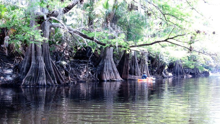
Intriguing rather than beautifully lush, the landscape of our Econ run varied from high sandy banks to low sandy beaches. At times, towering cypress dwarfed us as we paddled past, water marks on their trunks evidence of higher water levels. Of course, there were oaks and cabbage palms, and we even spotted a couple magnolia trees nudging themselves between the larger trees. However, without the benefit of spring waters and with little or no rain in the area for a very long time, the water level was low, leaving the worn, depleted banks with trees clutching to their sides. At times, deadfalls challenged us, as we were forced to paddle either through or over them.
Amazingly, the low water level did not deter the birds as we saw many! We spotted three bald eagles, one quite large, and we were treated to a great blue heron that seemed to await us at each river bend, flying off as we approached, to scout ahead. We saw blue herons, swallow-tailed kites, vultures, and red- shouldered hawks. Bill even spied a wild turkey just before it ducked behind a log. Two alligators crossed our path—the larger one, about 10 feet long, slid into the water ahead of us, pausing while we paddled closer, and then disappeared slowly somewhere beneath us.
There never seems to be enough time when paddling a Florida river. We had hoped to make it to the St. Johns, about a 12-mile run. However, after two hours of paddling and a short snack break and nature scout, we turned around and headed back to Snow Hill Bridge.
I’d love to return to this river someday—after a tropical storm, when its “valley of paleo-dunes” are overflowing–and paddle the entire 35 miles. It was a beautifully intriguing river with so much character.
